Creating a custom illustrated map is both an art and a science. When visitors hold a beautifully illustrated tourist map in their hands, they rarely consider the intricate process behind its creation. At Mapful.art, transforming complex locations into visually engaging, informative, and culturally sensitive maps requires meticulous planning and artistic vision. Join us as we unveil the creative journey behind the Akesai County Boluo Zhuanjing Film and Television Base Tourist Map – a cartographic masterpiece that guides visitors through China's cinematic desert landscape.
Initial Client Consultation and Requirements Gathering
Every successful map begins with understanding the client's vision. For the Akesai County project, our team conducted comprehensive consultations with representatives from the film and television base to gather crucial information:
- The specific layout of the expansive desert filming location
- Key attractions and points of interest requiring emphasis
- Intended visitor flow and common tourist routes
- Cultural and historical significance of the site
- Brand identity and visual style preferences
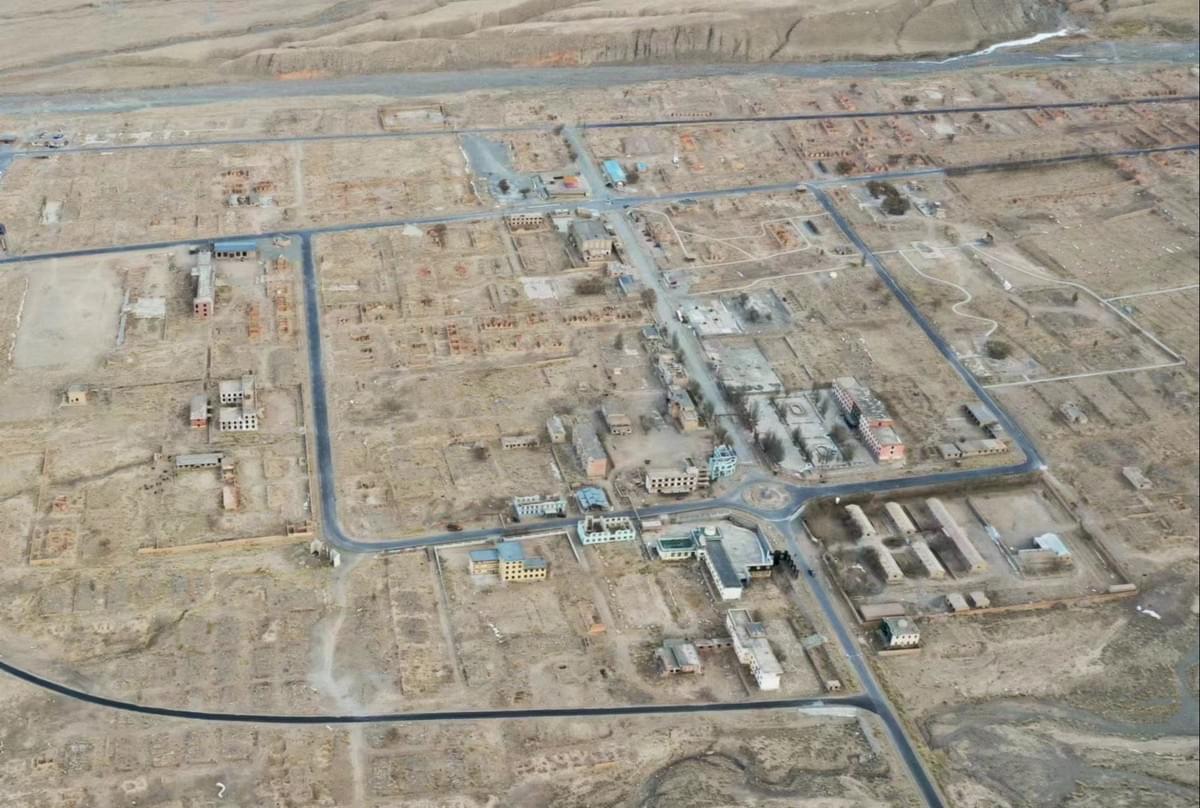
This desert-based production facility presented unique challenges. The map needed to provide practical navigation while capturing the atmospheric essence of this remote filming location – where countless Chinese productions have brought stories to life against the backdrop of stunning desert landscapes.
Research and Site Analysis
Before putting pencil to paper (or stylus to tablet), our team embarked on thorough research:
- On-site exploration: Walking the grounds to understand physical layout and terrain
- Visual documentation: Collecting reference photos of buildings, landmarks, and natural features
- Environmental assessment: Studying the distinctive desert environment and its visual characteristics
- Topographical analysis: Mapping elevation changes and distinctive land features
- Visitor behavior observation: Understanding how tourists naturally navigate the space
For Akesai County's map, we paid special attention to the striking contrast between architectural elements and the surrounding desert landscape. The film sets – ranging from historical recreations to fantasy environments – required careful documentation to ensure accurate yet aesthetically pleasing representation.
Conceptualization and Style Development
Developing the map's visual language was a critical creative decision. After multiple concept sketches, we settled on:
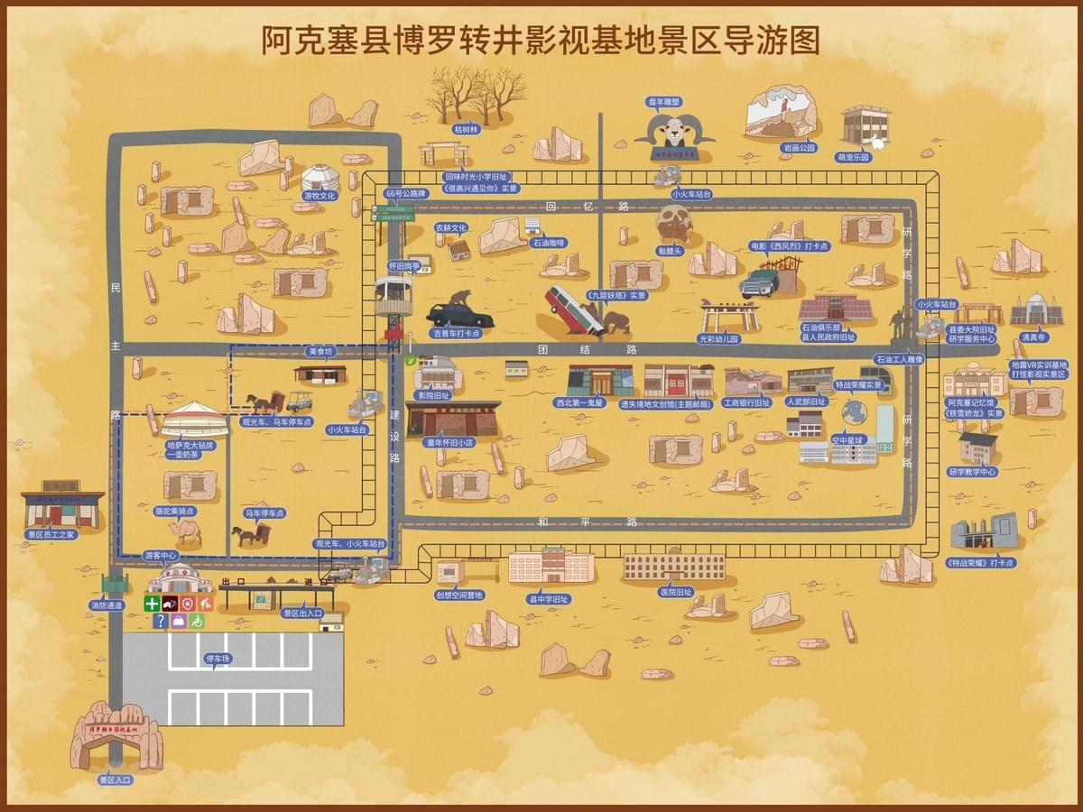
- A warm, ochre-yellow background that evokes the sun-baked desert setting
- Simplified yet instantly recognizable representations of buildings and landmarks
- A cartoon-inspired style balancing approachability with visual interest
- An illustration approach maintaining geographical accuracy while enhancing appeal
- Chinese typography that harmonizes with the overall aesthetic
Each stylistic decision was made with both aesthetic and functional considerations in mind. The final approach needed to delight visitors while efficiently guiding them through this sprawling film base.
Digital Illustration Process
With concept approved, our illustrators began the meticulous digital creation process:
- Base Layout Creation: Establishing geographic fundamentals using GPS data and official site plans
- Road Network Design: Depicting pathways with appropriate visual hierarchy to indicate main and secondary routes
- Landmark Illustration: Creating distinctive representations of key buildings and attractions
- Terrain Representation: Stylizing the desert landscape with characteristic rock formations and terrain features
- Labeling and Typography: Integrating Chinese character labels that balance readability with visual harmony
- Color Application: Implementing a carefully selected palette reflecting the environment while ensuring clarity
- Navigation Elements: Adding legends, orientation markers, and scale indicators
The buildings were rendered in a consistent style that made them easily identifiable while maintaining the artistic cohesion across the entire map. Special attention was given to distinctive architectural elements that would serve as visual landmarks for visitors.
User Experience Considerations
Beyond artistic merit, the map's success depends on visitor usability. Our design prioritized:
- Clear visual hierarchy highlighting main attractions and facilities
- Strategic color coding to differentiate areas and functions
- Prominent, legible labeling of key locations and services
- Intuitive layout following natural visitor flow patterns
- Practical elements like entrances, exits, and amenities clearly marked
- Appropriate scale balancing detail with overall readability
We repeatedly asked ourselves: "Will a first-time visitor be able to navigate confidently with this map?" This user-centered approach guided numerous refinement decisions.
Cultural and Contextual Sensitivity
Creating a map for this Chinese cultural destination required careful attention to:
- Authentic representation of traditional architectural elements
- Proper Chinese character usage and placement
- Cultural context of the film sets and their significance
- Visual storytelling that enhances the visitor's connection to the location
- Balance between practical wayfinding and aesthetic appeal
The final map serves as both a functional tool and a cherished souvenir that captures the essence of this unique film and television production base – a memento of the visitor's journey through China's cinematic landscape.
Final Production and Implementation
Upon client approval, our team prepared the map for various applications:
- Digital optimization for different reproduction methods
- Integration with visitor guides and promotional materials
- Adaptation for on-site signage and digital platforms
- Final quality assurance and language verification
The Finished Journey
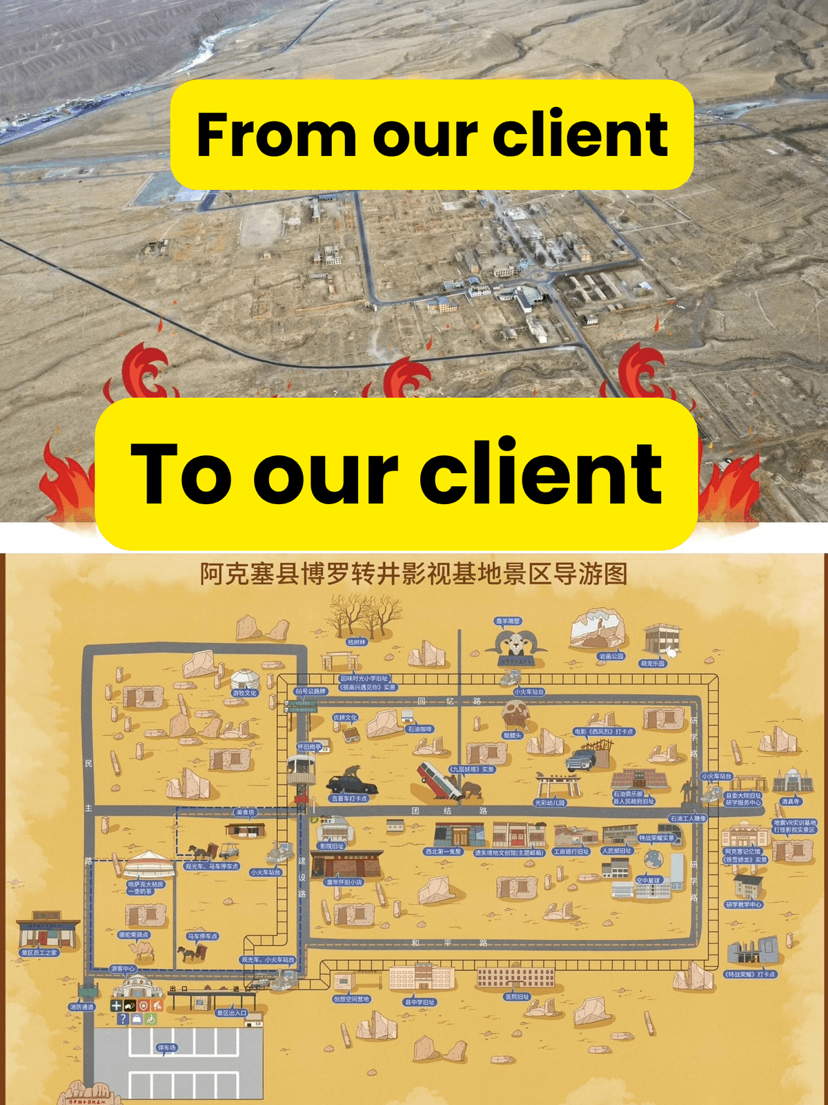
The completed Akesai County Boluo Zhuanjing Film and Television Base tourist map represents the culmination of artistic vision, technical precision, and cultural understanding. What began as client requirements evolved through research, conceptualization, and meticulous illustration into a functional artwork that enhances thousands of visitor experiences.
At Mapful.art, we believe that the best illustrated maps do more than guide – they tell stories, evoke emotions, and become part of the visitor's journey. Whether navigating Chinese film sets in the desert or any other unique destination, our process ensures that each map is as exceptional as the location it represents.
Have a unique location that deserves custom cartographic storytelling? Contact Mapful.art to begin your map creation journey.