


Mapful.art
Where Maps Stop Being Boring and Start Being Legendary 🗺️✨
Mapful.art
Where Maps Stop Being Boring and Start Being Legendary 🗺️✨
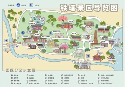
IRON TOWER SCENIC AREA: Where Lost Tourists Become Navigation Legends! 🗼🗺️
Regular tourists: “According to Google Maps, the ancient temple is… inside that public bathroom?”
You, with the Mapful.Art map: “Behold! The iconic tower stands right between the perfectly illustrated cherry blossoms and the historically accurate temple on this hand‑drawn masterpiece.” 🌸
Why this map makes digital navigation weep
- 3D buildings that look like buildings: No more mistaking a storage shed for a “priceless monument.”
- Cherry blossoms and garden cues: Seasonal trees, pavilions, and bridges drawn so clearly you’ll stop walking in scenic circles.
- Toilets, clearly labeled: Because your bladder does not care how beautiful the skyline is.
- Designated smoking areas: Enjoy your break without turning a 300‑year‑old wooden pavilion into a cautionary tale.
- Bilingual labels (EN + 中文): Point, nod, and be understood—zero translation charades.
- White route loops: The optimal circuit, so you don’t exit through a service gate while thinking you’ve discovered a “local secret.”
- Photo‑spot intel: Framed viewpoints (including “behind the third pavilion”) to capture the tower without fifty random strangers.
- Accessibility and family‑friendly icons: Gentle paths, stroller‑friendly segments, benches, shade, and water refill points.
- Offline and battery‑proof: Works perfectly when your phone signal decides it’s on tea break.
While others follow a group of equally lost strangers, you’re gliding from gate to garden to tower like you rehearsed it.
The souvenir that prevents disasters
Other visitors: “We spent all day following people we thought were tour guides—they were just… confident and lost.”
You: dramatically unfolds Artistic Treasure
“According to this cartographic masterpiece, the perfect tower shot is behind the third pavilion, then we loop past the blossom path, grab tea, and catch the drum show—on time.”
The only map that keeps you on the right paths and out of the wrong doors. 🇨🇳🏮🧭
How your perfect visit actually plays out
- Morning: Tower overview → blossom walk → shaded tea stop.
- Midday: Temple courtyard → garden bridges → photo spot with no crowds.
- Afternoon: Pavilion loop → quiet lawn for a snack → easy exit on the white route.
From “lost in a lovely maze” to “park whisperer with excellent timing.”
For destinations, parks, museums, and DMOs
Cartographer of Hidden Gems | Chinese Social Media Wizard
We don’t just bring Chinese backpackers to your doorstep—we make sure they explore everything around it.
- Phase 1: Explosive Chinese social media marketing (小红书 RED, 微信 WeChat, 微博 Weibo) puts your destination in front of 150M+ travelers.
- Phase 2: Mandarin‑first, bilingual adventure maps turn “I’m lost” into “I get it”—so visitors stay longer and spend more.
Your local secrets + our bilingual navigation = explorers who find the right gates, the right gardens, and the right viewpoints at the right time.
What we deliver:
- Heritage‑smart park maps with crowd‑savvy routing and photo‑spot intel
- Family‑friendly circuits with toilets, water, shade, and accessibility notes
- Premium print maps and shareable digital versions with QR mini‑guides
Need dedicated Chinese social media or digital services?
Visit our partner: www.chinaful.link


