


Mapful.art
Where Maps Stop Being Boring and Start Being Legendary 🗺️✨
Mapful.art
Where Maps Stop Being Boring and Start Being Legendary 🗺️✨
MOUNT TIANZHU: Where Regular Hikers Get Lost—and Map Holders Become Mountain Masters! 🏔️🗺️
Regular tourists: squinting at phone GPS
“According to this, we’re currently… swimming in a lake?”
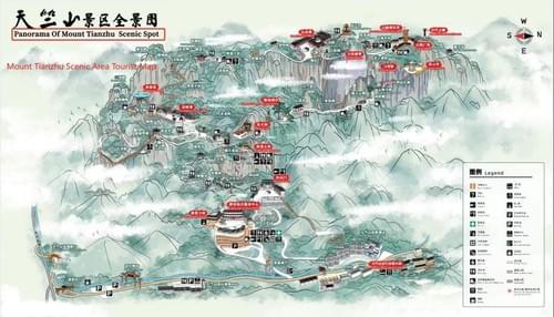
You, with the Mapful.Art map: “Behold—the ancient temple nestled between the third and fourth misty peak, exactly as shown on this Chinese landscape masterpiece.” 🧙♂️
Why this map makes your phone cry
- Real shanshui vibes, real navigation: Ink‑style mountains and ridgelines that make you look like a cultural scholar while subtly steering you away from cliffside whoopsies.
- Color‑coded landmarks that matter: Historic shrines, pavilions, restrooms, tea houses, first‑aid, and shuttle stops—clearly distinct, zero embarrassment.
- Misty‑peak accuracy: Viewpoints and photo decks marked so well even influencers would pay for your route.
- Bilingual labels (EN + 中文): Point, nod, and go—no translation gymnastics required.
- Trail grades and elevation cues: Gentle strolls, moderate climbs, and “maybe not after lunch” sections, with ascent arrows and distance markers.
- White route loops: Optimal circuits that avoid dead ends, service roads, and “how did we get here?” moments.
- Safety and comfort intel: Toilets, shade shelters, water refill points, benches, no‑entry zones, and last‑bus times—front and center.
- Offline and battery‑proof: Works when your phone chooses cloud contemplation over GPS.
While others orbit the same boulder three times, you’ll glide from gate to temple to ridge like you trained for this.
The souvenir that prevents disasters
Other hikers: “We’ve been looping for three hours and might need a helicopter.”
You: dramatically unfolds Artwork
“According to this panoramic masterpiece, we follow the cute illustrated path past the waterfall, then descend the ridge loop—back at the visitor center by afternoon tea.”
The only map that doubles as emergency‑level clarity in the wild and wall‑worthy art at home. 🇨🇳⛰️🧭
How your mountain‑master day actually plays out
- Morning: Temple bells → misty overlook → shaded tea pavilion.
- Midday: Waterfall path (photo icon right after the bridge) → picnic bench with a view.
- Afternoon: Ridge loop with easy descent → quiet bamboo grove → restroom + refill.
- Evening: Golden‑hour platform → white route back for snacks and a shuttle that you actually catch.
From “lost blue dot” to “trip leader with perfect timing.”
For destinations, parks, mountains, and DMOs
Cartographer of Hidden Gems | Chinese Social Media Wizard
We don’t just bring Chinese backpackers to your doorstep—we make sure they explore everything around it.
- Phase 1: Explosive Chinese social media marketing (小红书 RED, 微信 WeChat, 微博 Weibo) puts your destination in front of 150M+ travelers.
- Phase 2: Mandarin‑first, bilingual adventure maps turn “I’m lost” into “I get it”—so visitors stay longer and spend more.
Your local secrets + our bilingual navigation = explorers who find the right shrine, the right ridge, and the right tea stop at the right time.
What we deliver:
- Mountain master maps with trail grades, elevation lines, and crowd‑savvy loops
- Heritage + nature “hidden gems” routes with photo‑spot and safety icons
- Premium print maps and shareable digital versions with QR mini‑guides
Need dedicated Chinese social media or digital services?
Visit our partner: www.chinaful.link

