
Mapful.art
Where Maps Stop Being Boring and Start Being Legendary 🗺️✨
Mapful.art
Where Maps Stop Being Boring and Start Being Legendary 🗺️✨
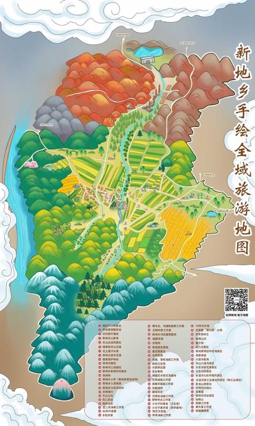
XINDI TOWNSHIP: Where Tourists Mistake Farms For Trails & Map Holders Become Legends! 🏞️🗺️
Regular tourists: staring at their phone
“According to GPS, the historic temple is... in the middle of this rice paddy?”
You, with the Mapful.Art map: “BEHOLD! The ancient temple is beyond the orange-red mountains next to the winding blue river surrounded by those striped agricultural patterns on my hand-drawn masterpiece!” 🏯
Why This Map Prevents Township Disasters
- Vibrant color coding: So you don't mistake "beautiful mountain hiking trail" for "steep cliff where only goats should venture!"
- Distinctive yellow-green agricultural patterns: Clearly marked so you don't wander through someone's carefully planted crops thinking it's a public park!
- Winding blue river: Acting as a constant reference point so you don’t confidently announce, “We just need to cross this river,” when you've already crossed it three times and are now in a completely different district!
- Calligraphy-inspired fonts: Making you look sophisticated while frantically scanning QR codes to learn how to say "I’m completely lost" in the local dialect!
The Map That Transforms Your Township Adventure
Other tourists: “We spent our entire day trying to find that famous lookout point and ended up at some farmer's storage shed where they store fertilizer.”
You: dramatically unfold township treasure
“According to this cartographic masterpiece, if we follow the blue river upstream past the traditional village, we'll discover the hidden viewpoint that perfectly frames both the orange-red mountains and the agricultural valleys. Then we can use the custom icons to locate that family restaurant that’s been serving the same recipes for 300 years! AND if we scan this QR code, we'll get the exact times when the local cultural performance happens that isn’t listed in any guidebook!”
The only map that transforms you from “confused foreigner standing in the middle of a cabbage field wondering why your GPS says you’ve reached a famous waterfall” to “township navigation expert who casually explains traditional agricultural patterns while effortlessly finding scenic spots that even the local postal workers don’t know about!” 🇨🇳🏞️🧭
Your ideal township exploration unfolds like this
- Arrival: Grab your beautifully crafted map and prepare for an adventure through the rich landscapes of Xindi Township!
- Smart Navigation: Move confidently through fields and valleys without fear of getting lost or intruding on local farms.
- Culinary Discoveries: Time your visits to indulge in authentic local dishes that have stood the test of time.
- Cultural Engagement: Discover performances and traditions that immerse you into the local way of life.
From “lost and frustrated” to “knowledgeable traveler sharing insights while enjoying the beauty of the land”!
For townships, tourism boards, and cultural sites
Cartographer of Hidden Gems | Chinese Social Media Wizard
We don’t just bring Chinese backpackers to your doorstep—we ensure they explore everything around it!
- Phase 1: Explosive Chinese social media marketing (小红书 RED, 微信 WeChat, 微博 Weibo) showcases your township to over 150 million travelers.
- Phase 2: Mandarin-first, bilingual adventure maps turn “I’m lost” into “I get it”—leading to longer stays and enriched visitors.
Your local secrets + our bilingual navigation = guests who cherish the unique experiences your township has to offer.
What we deliver:
- Engaging, colorful maps showcasing routes to key sites and local attractions clearly marked
- Visitor-friendly pathways ensuring everyone enjoys a meaningful exploration of Xindi Township
- Premium print maps and shareable digital versions for both onsite and online use
Need dedicated Chinese social media or digital services?
Visit our partner: www.chinaful.link


