
Mapful.art
Where Maps Stop Being Boring and Start Being Legendary 🗺️✨
Mapful.art
Where Maps Stop Being Boring and Start Being Legendary 🗺️✨
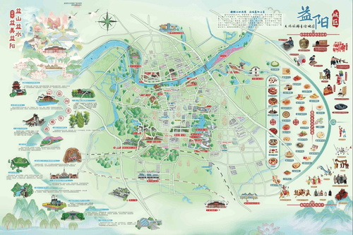
YIYANG: Where GPS Thinks You’re Swimming—and Map Holders Become River Gods! 🌊🗺️
Regular tourists: “According to GPS, we’re… standing in the middle of a river?”
You, with the Mapful.Art map: “Relax. We’re 200 meters from the exquisitely illustrated temple, tucked between the artist‑drawn waterways on this hand‑crafted masterpiece.” 🏞️
Why this map makes phone navigation look silly
- Real rivers, real bridges, real choices: Waterways, crossings, and riverfront paths are clearly marked—no ‘shortcut’ that turns into swim practice.
- Point‑and‑order food panels: Margin illustrations of local dishes so you can order like a pro without playing restaurant charades.
- See‑it‑from‑afar landmarks: Oversized, charming landmarks you can spot from a distance—no more squinting at a tiny blue dot.
- Classic Chinese artistry: Clouds, waves, and motifs that make you look culturally savvy while you’re actually hunting for the nearest restroom.
- Bilingual labels (EN + 中文): Point, nod, and go—zero translation gymnastics.
- River‑smart routing: Scenic loops and safe detours along the Zijiang River (资江) and the broader Dongting Lake area that make waterfront time effortless.
- Offline and battery‑proof: Works perfectly when your signal fades and your power bank is “definitely in the other bag.”
While others drift between “maybe the right bank?” and “maybe the right bridge?”, you’ll glide straight to the good stuff.
The souvenir that saves vacations
Other tourists: “We ate at the same convenience store for three days. We couldn’t find real restaurants.”
You: unfolds your Artistic Treasure, dramatically
“According to this cultural masterpiece, the famous noodle shop is just past the second bridge—origin story dating back to the Ming—then it’s a riverwalk to the sunset viewpoint.”
The only map that helps you feel “益山益水益美益阳” (Beautiful Yiyang—richer in mountains, waters, and charm) without actually falling into said mountains and waters. 🇨🇳🏮🧭
How your day actually plays out
- Morning: Temple and old‑street stroll, snack stop circled in the margin.
- Afternoon: Bridge‑to‑bridge riverwalk, ferry icon = photo spot, café with shade.
- Evening: Waterfront market, lantern views, easy route back—no mystery alleys.
From “lost among waterways” to “river‑route genius who arrives calm, fed, and on time.”
For destinations, waterfronts, hotels, and DMOs
Cartographer of Hidden Gems | Chinese Social Media Wizard
We don’t just bring Chinese backpackers to your doorstep—we make sure they explore everything around it.
- Phase 1: Explosive Chinese social media marketing (小红书 RED, 微信 WeChat, 微博 Weibo) puts your destination in front of 150M+ travelers.
- Phase 2: Mandarin‑first, bilingual adventure maps turn “I’m lost” into “I get it”—so visitors stay longer and spend more.
Your local secrets + our bilingual navigation = explorers who find the noodle alley, the quiet pier, and the riverside viewpoint they’ll rave about.
What we deliver:
- City “hidden gems” trails (food, culture, riverfront strolls)
- River and canal master maps with crossings, ferry points, and QR mini‑guides
- Premium print maps and shareable digital versions for onsite and online
Need dedicated Chinese social media or digital services?
Visit our partner: www.chinaful.link
