Have you ever wondered about the creative process behind those charming illustrated maps that perfectly capture a destination's essence? Today, we're taking you behind the scenes of Mapful.Art's creation of the Dayu Haitang illustrated map—a colorful representation of this stunning coastal area in Hainan, China. From initial client meetings to the final digital touches, discover how geographical accuracy meets artistic expression in this captivating cartographic journey.
Understanding the Vision: Client Consultation
Every great map begins with a conversation. The Mapful.Art team kicked off the Dayu Haitang project with an in-depth client consultation that established the foundation for the entire creative process. During these initial meetings, the team:
- Explored the client's vision for representing Dayu Haitang Bay's unique coastal landscape
- Identified the key landmarks and attractions that would define the map's focal points
- Determined the visual style that would best appeal to tourists and visitors
- Selected a vibrant color palette reflecting the region's tropical atmosphere
- Established which textual elements and labels would guide visitors through the area
This collaborative approach ensured that the final map would not only be visually appealing but would also serve its practical purpose as a navigation tool for visitors.
Laying the Groundwork: Research and Planning
Before any illustration work began, the Mapful.Art team immersed themselves in understanding Dayu Haitang's geography and character through:
- Gathering comprehensive geographical data about the bay area
- Researching notable features including mountains, beaches, architectural landmarks, and popular recreational activities
- Creating preliminary sketch layouts to organize spatial relationships while maintaining artistic freedom
- Identifying priority attractions that would receive special visual emphasis
This research phase transformed the team from artists into temporary geographical experts, ensuring that their creative interpretation would be built upon a foundation of accuracy.
Bringing the Map to Life: Design and Illustration
With a clear vision and solid research in place, the illustration process began in earnest:
Creating the Base Map
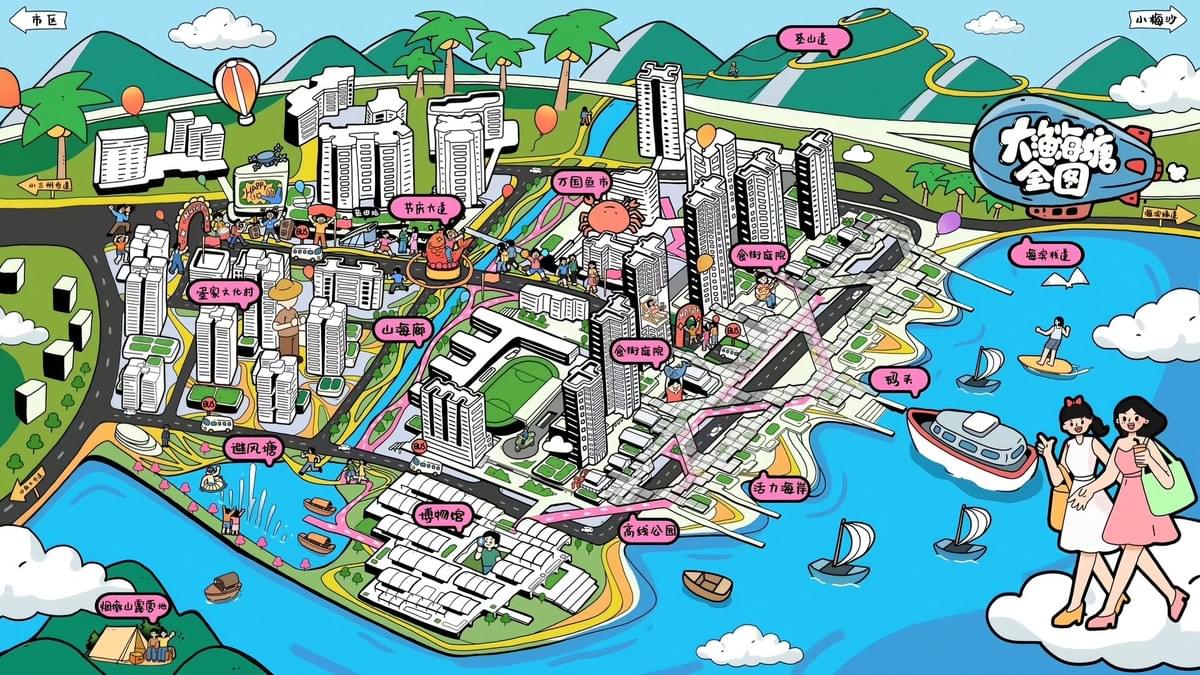
The team developed a cartoonish yet geographically accurate base map that struck the perfect balance between precision and artistic expression. The bird's-eye perspective was carefully chosen to showcase both the stunning coastline and urban developments that make Dayu Haitang unique.
Landmark Development
Each building and landmark was illustrated with distinctive silhouettes that visitors could easily recognize, creating visual anchors throughout the map. The team paid special attention to architectural details that capture each structure's character.
Adding Life and Movement
To transform the map from a static representation to a vibrant scene, the artists incorporated:
- Hot air balloons drifting across the sky
- Boats dotting the crystal blue waters
- Whimsical characters engaged in various activities
- Subtle animations of life throughout the landscape
Natural Element Integration
The region's stunning natural features received special attention:
- Mountains rendered with subtle shading techniques
- Water bodies with textured patterns suggesting movement
- Lush greenery represented in varied hues to indicate different vegetation types
- Carefully placed pathways and roads that help visitors understand navigation options
Informative Details: Adding Context Through Labels
The artistic elements were complemented by thoughtfully placed informational components:
- Chinese language labels identifying districts and neighborhoods
- Icons highlighting recreational areas and tourist attractions
- Color-coded waterfront features for easy identification
- Clearly marked urban centers and commercial districts
This layer of information transformed the beautiful illustration into a functional guide, ensuring visitors could appreciate the artistry while navigating the actual location.
Polishing to Perfection: Digital Finalization
The final production stages brought everything together:
- Hand-drawn elements were carefully digitized while preserving their artistic character
- Colors were fine-tuned to achieve a cohesive, vibrant aesthetic throughout the map
- Label placement underwent multiple revisions to ensure perfect positioning and legibility
- The title "大渔海塘全图" (Complete Map of Dayu Haitang) was prominently positioned
- Final decorative characters were added to enhance the friendly, approachable feel
The Final Result: Art Meets Information
The completed Dayu Haitang illustrated map stands as a testament to Mapful.Art's ability to blend geographical accuracy with artistic vision. The vibrant, cartoon-style illustration succeeds in making complex spatial information not just accessible but genuinely enjoyable to explore.
Beyond its practical value for tourists navigating this beautiful coastal destination, the map serves as a souvenir-worthy representation of the area's character and charm. It invites viewers to visually explore Dayu Haitang before they even arrive, building excitement and helping them plan their perfect visit.
Through careful attention to detail, artistic skill, and geographical knowledge, the Mapful.Art team created more than just a map—they crafted a visual story of a destination, inviting tourists and locals alike to see Dayu Haitang through fresh, appreciative eyes.
Have you used an illustrated map like this one on your travels? How did it enhance your experience of the destination? Share your thoughts in the comments below