Introduction
In a world dominated by digital navigation apps and satellite imagery, there's something undeniably special about a hand-drawn map. It captures not just the geography of a place, but its essence and character. The Mapful.Art team recently completed a stunning illustrated tourism map for Shangrao City District that exemplifies this perfect blend of artistry and functionality. This beautiful creation doesn't just show visitors where to go—it invites them on a journey, highlighting the city's unique charm through carefully crafted illustrations and thoughtful design. Let's peek behind the curtain to discover how professional map artists transform geographic data into visual storytelling masterpieces.
The Creative Journey Begins: Client Consultation
Every great map starts with a conversation. For the Shangrao project, the Mapful.Art team likely began with extensive discussions with local tourism officials to understand their vision. These initial consultations are crucial for establishing:
- The map's primary purpose and target audience
- Key attractions and landmarks that must be featured
- The desired aesthetic and emotional response
- Cultural elements that should be honored and highlighted
- Practical considerations like size, format, and distribution plans
For Shangrao, officials likely emphasized the need for a bright, welcoming style that would appeal to visitors while accurately representing the city's layout and attractions. These early discussions lay the foundation for the entire creative process.
Research and Information Gathering
Before any drawing begins, thorough research is essential. The Mapful.Art team would have:
- Studied existing maps and geographical data for accuracy
- Identified and prioritized landmarks, parks, and cultural sites
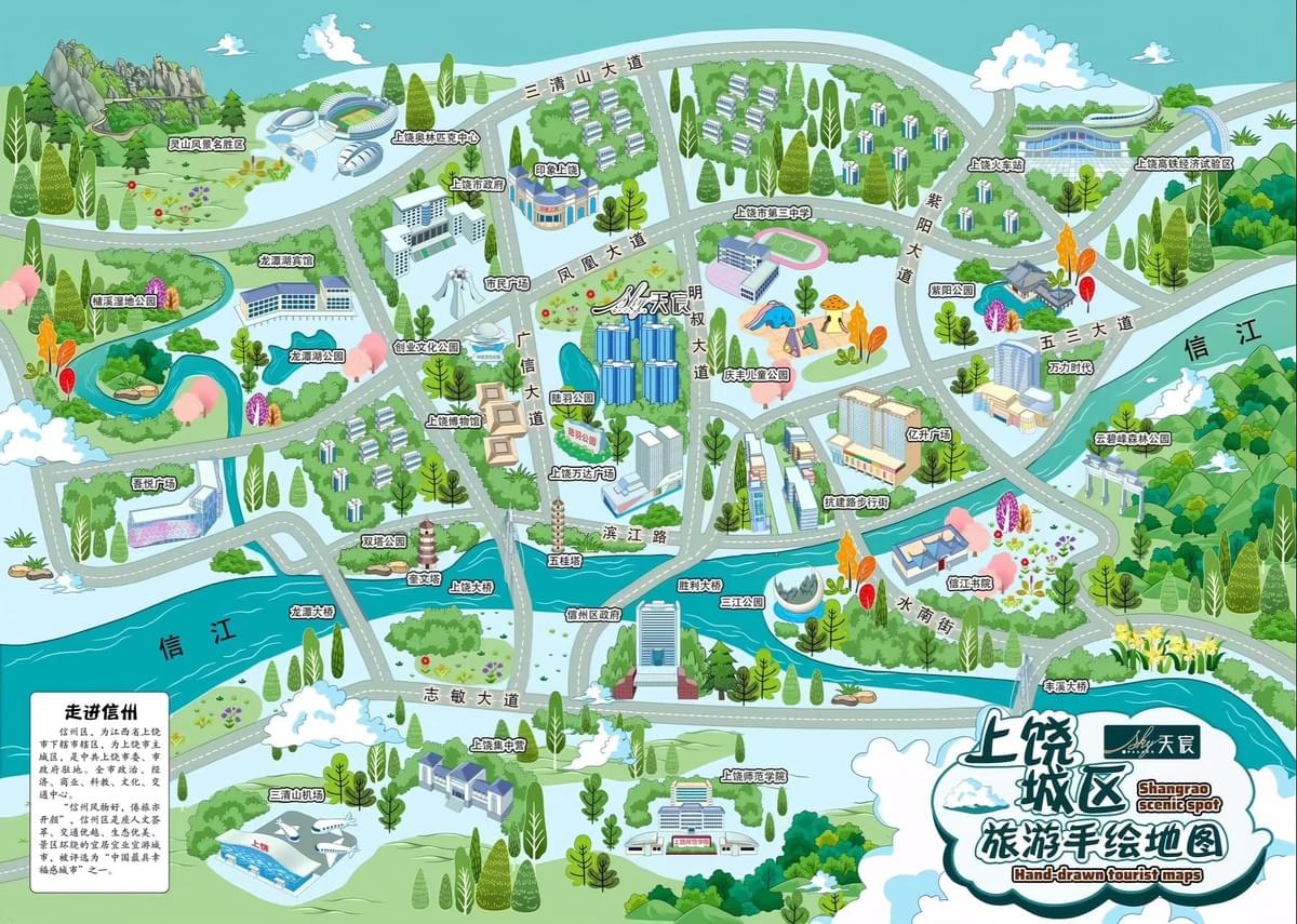
- Mapped critical infrastructure like 三清山大道 (Sanqing Mountain Avenue) and 信江路 (Xinjiang Road)
- Documented the flow of 信江 (Xinjiang River) and other waterways that shape the city
- Photographed distinctive architectural features to ensure recognizable representations
- Researched local color palettes and architectural styles
This research phase ensures that the final map, while artistic, remains rooted in geographical reality—striking the perfect balance between creativity and functionality.
Conceptualization and Style Development
With research complete, the artists begin developing the map's unique visual language. For Shangrao, the team created a distinctive style characterized by:
- A vibrant turquoise palette for water features that draws the eye
- Stylized, cartoon-like buildings that maintain recognizable architectural elements
- Strategic exaggeration of important landmarks for improved visibility
- A simplified road network focusing on orientation rather than exact scale
- Thoughtful use of pink, orange, and green accents creating visual harmony
- Decorative elements like stylized clouds and trees that add personality
This conceptual phase requires multiple iterations as the team experiments with different approaches until they find the perfect visual language for the project.
The Digital Illustration Process
With the style established, the artists begin the meticulous illustration process:
- Creating the geographical foundation: The team starts with an accurate base layout positioning major elements correctly
- Building the landscape: Adding terrain features, waterways, and green spaces
- Illustrating landmarks: Developing detailed renderings of key buildings and attractions
- Adding transportation networks: Incorporating roads, bridges, and transit hubs
- Layering in details: Including trees, decorative elements, and visual texture
- Incorporating text: Adding Chinese labels that balance readability with aesthetic integration
Each element requires careful attention to detail while maintaining consistency with the overall style. The process combines traditional artistic skills with digital tools, allowing for precision while preserving the warm, hand-crafted feel.
Balancing Information and Aesthetics
Perhaps the greatest challenge in creating tourism maps is balancing information density with visual appeal. Too much detail overwhelms viewers; too little leaves them disoriented. The Shangrao map successfully navigates this challenge by:
- Prioritizing landmarks based on visitor relevance
- Using color coding to distinguish different types of attractions
- Employing visual hierarchy to guide the eye to important features
- Simplifying complex areas while maintaining recognizable forms
- Integrating text labels that inform without cluttering
This delicate balance ensures the map serves its practical purpose while remaining visually engaging—a crucial consideration for tourism applications.
The Final Product: More Than Just a Map
The completed Shangrao City District map transcends ordinary cartography to become both a functional guide and a piece of art. Unlike standard GPS maps, this hand-drawn creation offers:
- A memorable first impression of the city's character and layout
- Cultural context through thoughtful representation of local architecture
- An emotional connection that sparks curiosity and excitement
- A practical orientation tool that highlights what's truly worth seeing
- A beautiful souvenir that extends the tourism experience
By combining geographical accuracy with artistic interpretation, the Mapful.Art team has created more than just a navigational tool—they've crafted a visual story that invites exploration and celebrates Shangrao's unique identity.
Conclusion
The Shangrao City District tourism map exemplifies how artistry and functionality can combine to create something greater than the sum of its parts. Through careful research, thoughtful design decisions, and skilled illustration, the Mapful.Art team has transformed geographical data into a compelling visual narrative that serves both practical and aesthetic purposes.
In our digital age, these handcrafted maps remind us that the most memorable way to understand a place isn't always through the clinical precision of satellite imagery, but through the interpretive lens of artistic vision. For visitors to Shangrao, this map offers not just directions, but an invitation to discover the city's character—one beautifully illustrated landmark at a time.