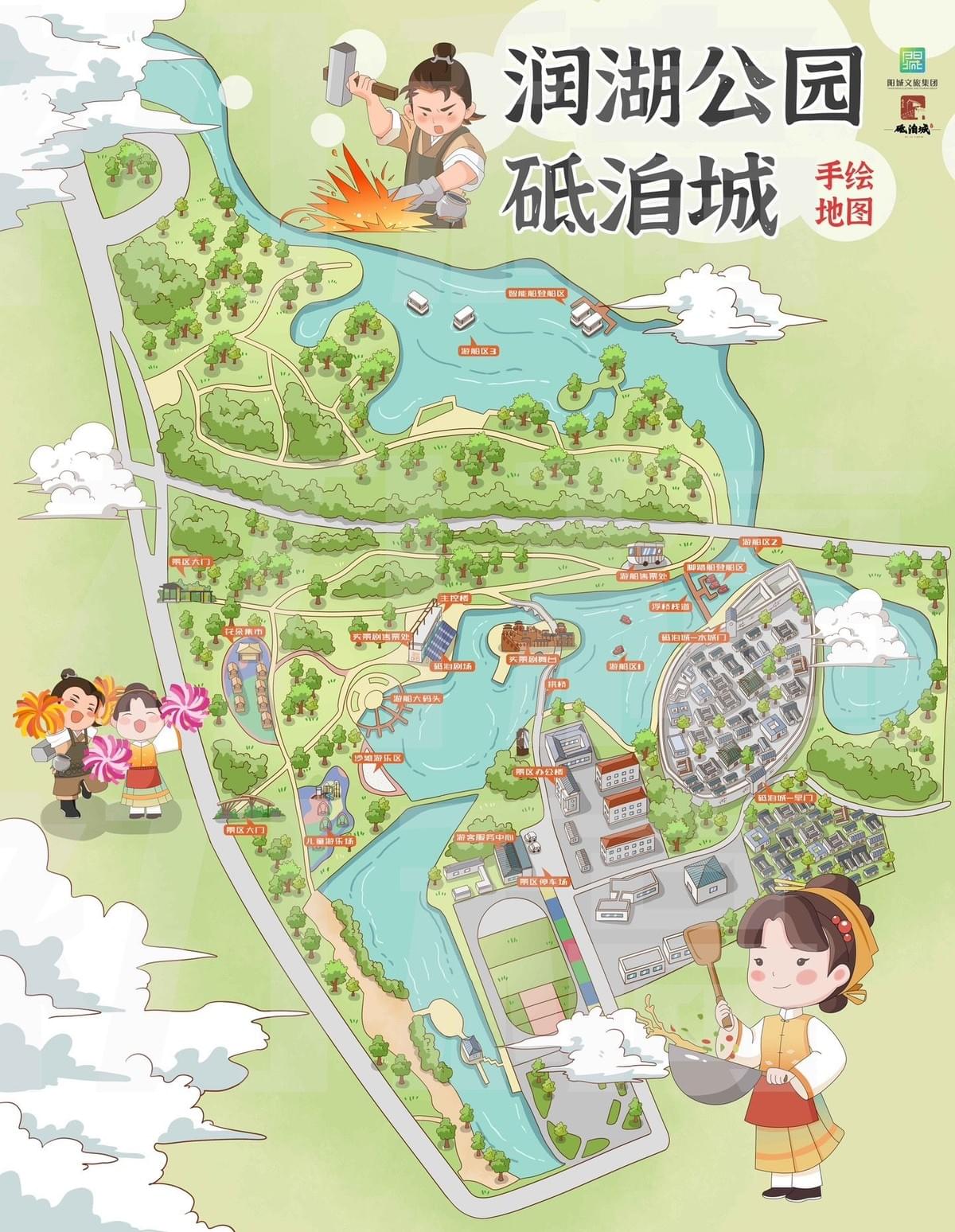
When you first glimpse a Mapful.art creation, you're not just looking at a map—you're experiencing a story told through colors, characters, and careful cartography. Our recently completed Runhu Park Dishi City (润湖公园砥洎城) project exemplifies this fusion of precision and artistic expression. But how exactly does a blank canvas transform into these vibrant navigational artworks? Join us as we pull back the curtain on our creative process.
The Creation Process
1. Initial Client Consultation
Every great map begins with conversation. For Runhu Park, our team met extensively with park management to:
- Understand their vision for visitor experience and wayfinding needs
- Identify the park's signature features requiring special attention
- Define the map's primary audience (a mix of tourists, families, and local visitors)
- Establish the artistic direction, settling on a style that would incorporate traditional Chinese character elements while maintaining visual clarity
This foundation of understanding ensures our artistic choices serve both aesthetic and practical purposes from the very beginning.
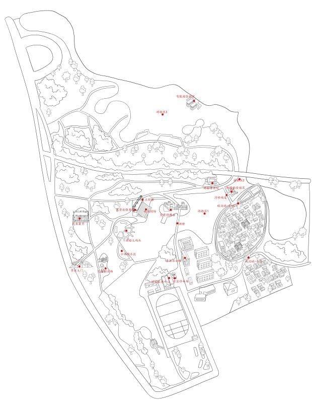
2. Data Collection & Site Survey
Art meets science as we immerse ourselves in the physical space:
- Our artists conducted multiple on-site visits, experiencing Runhu Park firsthand through different times of day
- We gathered precise GPS coordinates and studied existing technical maps
- Hundreds of photographs captured the unique architectural details and natural elements
- Detailed notes documented pathways, facilities, and viewpoints that would need representation
These explorations provided the authentic details that would later make the map not just beautiful, but genuinely useful.
3. Conceptual Design
With raw data in hand, our creative vision began taking shape:
- Initial sketches focused on the park's distinctive blue waterways as the central organizing element
- We developed charming cartoon character concepts based on traditional Chinese figures
- A light green color palette was chosen to emphasize the natural environment while ensuring readability
- Multiple layout options were drafted, each balancing geographical accuracy with artistic interpretation
During this phase, we presented preliminary concepts to the client, allowing their feedback to guide our development of the map's personality.
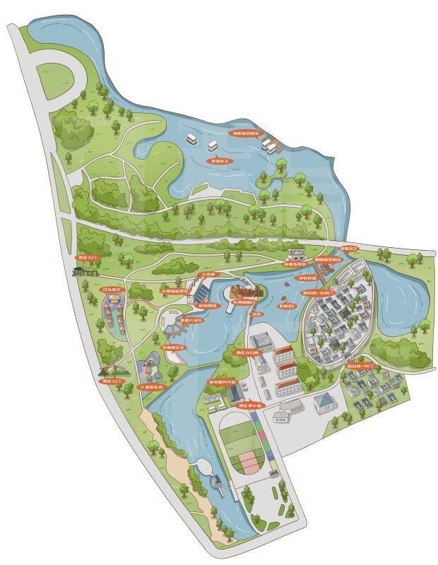
4. Digital Illustration
This is where magic happens as sketches transform into vibrant illustrations:
- Approved conceptual drawings were meticulously converted to digital format
- Our artists created custom watercolor-style textures for the background, giving the map depth
- Each building, tree, and pathway was individually illustrated with attention to their distinctive characteristics
- Character illustrations—like the iconic blacksmith with hammer—were integrated to reflect local culture
- Decorative clouds and traditional artistic elements were added to enhance the map's aesthetic appeal
Every pixel was purposefully placed to balance visual delight with navigational clarity.
5. Information Integration
A beautiful illustration becomes a useful map when information is thoughtfully incorporated:
- Location markers in bright orange were strategically placed for maximum visibility
- Points of interest were labeled in Chinese with careful typography
- Pathways were clearly distinguished using varying line weights and styles
- Key facilities received custom icons that aligned with the overall artistic direction
- Legend elements were designed to be intuitive while maintaining the map's visual language
This layer of information transforms the artwork from something merely beautiful to behold into a tool that guides and informs.
6. Client Review & Refinement
Collaboration remains central as the map nears completion:
- Multiple review sessions with Runhu Park management allowed for real-time feedback
- Adjustments to colors, proportions, and featured elements were made based on client input
- We verified geographical accuracy while preserving the charming artistic style
- Fine details were polished until the map perfectly aligned with client expectations
This iterative process ensures the final product serves its purpose while exceeding artistic expectations.
7. Finalization & Delivery
The culmination of our creative journey:
- High-resolution files were prepared for various applications from large display panels to mobile screens
- Format variations were created for different uses—brochures, wayfinding signs, website integration
- Both print-ready CMYK files and web-optimized RGB versions were delivered
- Documentation was provided to support future updates or extensions of the map
The Finished Product
The completed Runhu Park Dishi City map successfully balances geographical accuracy with artistic charm, creating an appealing visual guide that enhances visitor experience while showcasing the park's unique character. The traditional Chinese character illustrations add cultural context, while the bright colors and clear labeling ensure the map remains practical and functional.
What sets a Mapful.art creation apart is this delicate balance—creating something that functions flawlessly as a navigational tool while standing alone as a piece of art worthy of framing. The Runhu Park project exemplifies our commitment to crafting maps that don't just show people where to go, but inspire them to explore.
Looking to bring your location to life through custom illustrated cartography? Contact the Mapful.art team to discuss your project today..