In the world of cartography and design, illustrated campus maps stand at a fascinating intersection of art, geography, and storytelling. The Beijing Jiaotong University Weihai Campus map created by the talented team at Mapful.Art represents a perfect example of how functional wayfinding tools can also be visually stunning pieces of art. This blog post takes you behind the scenes of this creative process, revealing how a blank canvas transformed into a comprehensive visual guide that captures both the physical layout and unique character of a university campus.
The Client Consultation Dance
Every great map begins with understanding its purpose. The Mapful.Art team initiated their project with a comprehensive consultation with Beijing Jiaotong University administrators to establish clear objectives. This crucial first step involved in-depth discussions about:
- The primary purpose of the map (orientation for new students, campus tours, marketing materials)
- Key landmarks and buildings that required highlighting
- The preferred artistic style and color palette that would align with the university's visual identity
- Target audiences, including prospective students, visitors, and new campus members
- Essential information to include, such as building names, facilities, and pathways
These initial conversations laid the foundation for a map that would not just guide but also engage and inspire its users.
Research: Getting to Know the Campus
Armed with client requirements, the Mapful.Art team dove into an extensive research phase:
- They conducted multiple site visits to photograph and document the campus layout firsthand
- Satellite imagery and existing maps were collected as geographical references
- Campus staff interviews helped identify important locations and common pathways
- A comprehensive inventory of buildings, landmarks, and facilities was created
This thorough exploration allowed the designers to understand both the physical space and the lived experience of the campus—how people moved through it, which buildings served as orientation landmarks, and what made this particular campus unique.
The Artistic Transformation
The design and illustration process is where science meets art. Based on the final image, the team employed a methodical yet creative approach:
Base Layout Creation
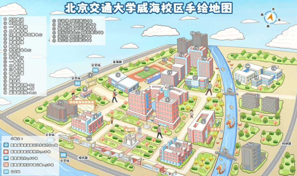
The designers began with an accurate geographical representation of the campus, carefully preserving its distinctive features, including the river flowing through the property. This geographical accuracy would ensure the map remained functional as a navigation tool.
Artistic Style Development
The team developed a friendly, cartoonish 3D illustration style characterized by:
- Simplified building shapes that maintained recognizable architectural features
- A bright, warm color palette dominated by pinks, blues, and greens
- Strategically exaggerated proportions to emphasize important campus buildings
- Decorative elements like stylized clouds and trees that added charm without cluttering the map
Digital Illustration Process
The illustrations were created using sophisticated digital tools:
- Vector-based software ensured clean, scalable graphics that would look sharp at any size
- Custom brushes created watercolor-like textures that softened the digital appearance
- Consistent lighting and shadow techniques gave depth and dimensionality to buildings
- A unified perspective view made the campus appear cohesive while highlighting key structures
Wayfinding System Integration
To ensure the map remained practical, the team:
- Implemented a numbered reference system for buildings
- Created a comprehensive legend on the left side for easy identification
- Clearly marked pathways, roads, and access points
- Added a compass in the top right corner for orientation
Detail Enhancement
The final touches brought the map to life:
- Character illustrations added scale and human interest
- Playful elements like fish in the river created visual discovery moments
- Color coding and visual hierarchy guided viewers' attention to important areas
- Decorative borders framed the composition beautifully
From Draft to Final Delivery
The creation process involved multiple revision cycles with university stakeholders. Each iteration refined the balance between artistic expression and functional clarity. The team responded to feedback, making adjustments to ensure accuracy while preserving the map's visual appeal.
The final deliverable was provided in various formats suitable for different applications:
- High-resolution digital files for online platforms
- Print-optimized versions for physical maps and brochures
- Vector formats allowing for future updates and modifications
- Interactive versions for digital displays around campus
What Makes This Map Special
Several key factors contribute to the exceptional quality of this illustrated campus map:
- Perfect Balance: The map strikes an ideal balance between geographical accuracy and artistic interpretation
- Visual Clarity: Despite its artistic nature, the map maintains exceptional navigational clarity
- Accessibility: Color coding, numbered references, and clear legends make location-finding intuitive
- Brand Alignment: The design incorporates university's visual identity through thoughtful color selection and styling
- Emotional Connection: The friendly, inviting illustration style creates a positive first impression of the campus
The Value Beyond Navigation
Beyond its practical purpose, this illustrated map serves as a powerful marketing tool for Beijing Jiaotong University. It transforms a simple campus layout into a vibrant community portrait that communicates the university's environment as welcoming and organized.
For prospective students and visitors, this artistic representation creates an emotional connection before they even set foot on campus. It showcases facilities in an accessible format while subtly communicating the university's attention to detail and student experience.
The Beijing Jiaotong University Weihai Campus map exemplifies how functional cartography can transcend into art—creating not just a navigation tool, but a visual story that captures the spirit and character of a place. Through thoughtful design choices and meticulous execution, Mapful.Art has delivered a map that will guide, delight, and inspire for years to come.