Introduction
In a world dominated by digital navigation and satellite imagery, there's something magical about a beautifully hand-drawn map. It doesn't just show you where to go—it invites you on a journey, tells a story, and captures the spirit of a place in ways that pixels and GPS coordinates simply cannot. The Zijing Village Scenic Area map created by the talented team at mapful.art stands as a perfect example of how traditional cartographic artistry continues to enhance our travel experiences in the modern age. This charming illustrated guide transforms a simple wayfinding tool into a keepsake that visitors will treasure long after their trip.
The Vision Behind the Map
Every great map begins with understanding its purpose. The mapful.art team embarked on their creative journey with comprehensive client consultations, working closely with Zijing Village representatives to align their artistic vision with practical tourism needs. This collaborative process established clear objectives: highlighting cultural landmarks like temples and bamboo groves, appealing to tourism demographics, and capturing the essence of traditional Chinese aesthetics while maintaining modern clarity.
The success of any illustrated map hinges on this initial alignment—creating something that is both beautiful to look at and functional to use. For Zijing Village, this meant developing a visual guide that would not only help visitors navigate the area but also communicate its cultural significance and natural beauty.
From Research to Rendering
Immersive Field Research
Long before the first sketch was drawn, the mapful.art designers likely conducted extensive on-site research:
- Walking every path to understand the terrain's contours and elevations
- Documenting key attractions through photographs from multiple angles
- Observing natural features like vegetation patterns and water elements
- Noting architectural details that define Zijing Village's unique character
This immersive approach provided the authentic foundation upon which the artistic interpretation could be built, ensuring the final product would feel true to the actual experience of visiting the area.
Conceptualization and Perspective
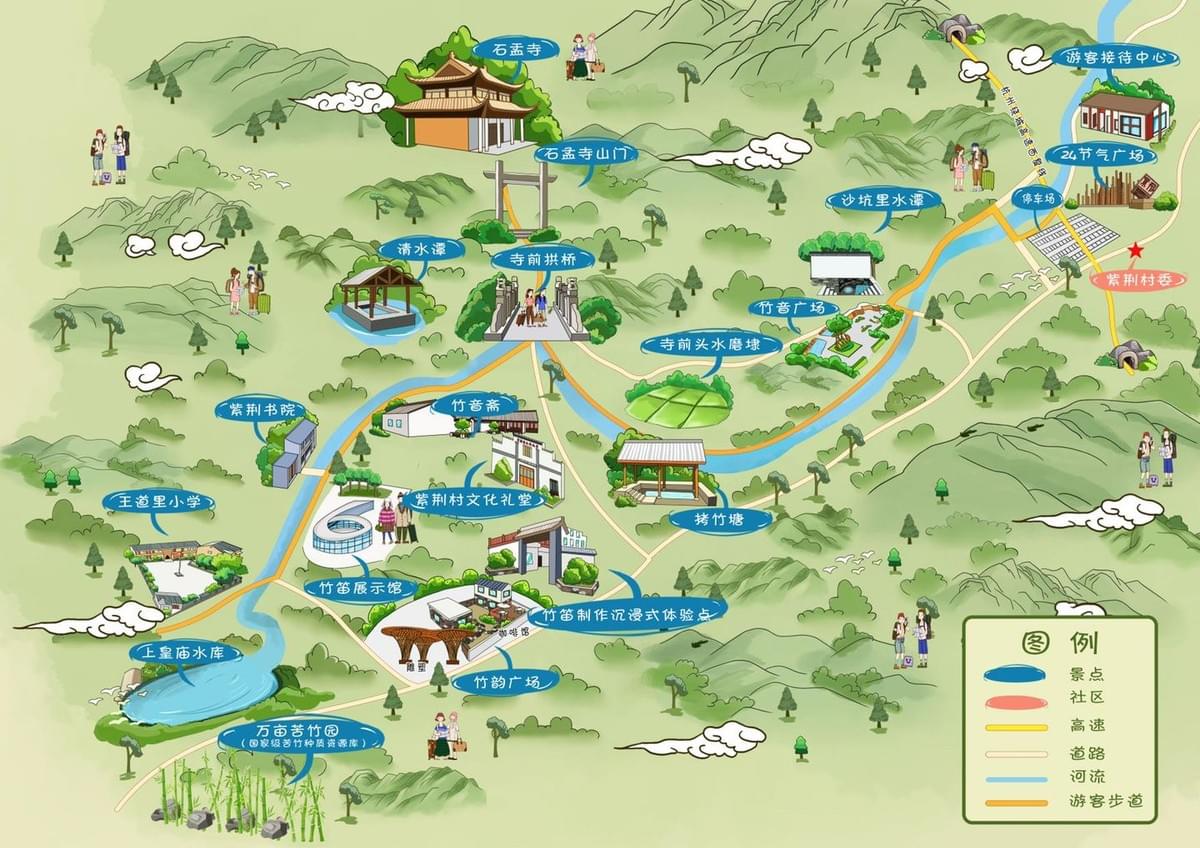
The Zijing Village map employs a three-dimensional perspective view—a deliberate choice that balances geographical accuracy with intuitive understanding. This bird's-eye perspective:
- Creates immediate visual comprehension of spatial relationships
- Allows for the artistic rendering of architectural details
- Provides natural depth that flat maps cannot achieve
- Gives viewers a sense of the landscape's character and flow
This perspective choice represents one of the most important decisions in illustrated cartography, setting the framework for all subsequent design elements.
Design Elements That Tell a Story
Visual Hierarchy and Color Theory
The map's effectiveness stems from its thoughtful visual hierarchy, guiding the eye naturally to important features through:
- Size differentiation for major and minor attractions
- A harmonious color palette featuring soft greens for natural areas, vibrant blues for water features, and warm earth tones for structures
- Subtle shading that creates depth and dimension
- Careful text placement that informs without overwhelming
The color choices aren't merely aesthetic—they serve practical functions while evoking the serene natural environment of Zijing Village, creating an emotional connection with viewers before they even visit.
Informative Detailing
The blue speech-bubble style labels represent a creative solution to a common cartographic challenge: how to provide necessary information without cluttering the visual experience. These distinctive markers:
- Create instant recognition of important sites
- Maintain visual consistency throughout the map
- Stand out against the background without disrupting the artistic flow
- Add a playful, accessible element to the design
Bringing the Map to Life
Perhaps the most charming aspect of the Zijing Village map is its inclusion of miniature human figures throughout the landscape. These small additions:
- Provide a sense of scale for buildings and natural features
- Add life and movement to static geographical representation
- Create narrative moments throughout the map
- Invite viewers to imagine themselves in the setting
The architectural rendering shows meticulous attention to detail, with traditional Chinese building features accurately depicted—from roof curves to structural elements—creating authentic representations rather than generic symbols.
Technical Mastery Behind the Art
Creating such a map requires a seamless blend of traditional artistic skills and modern technical capabilities:
- Initial concepts likely began as hand sketches capturing the essence and energy of the location
- Digital tools then allowed for precision, revisions, and color experimentation
- Geographic Information System (GIS) data may have provided the underlying accuracy
- Vector graphics ensured clean lines and future scalability for different print sizes
- Digital coloring techniques created the seamless gradients and textures
This combination of old and new approaches represents the evolution of cartographic art in the modern era—honoring traditional techniques while embracing technological advantages.
Conclusion
The Zijing Village Scenic Area map demonstrates why hand-drawn cartography remains relevant and valuable in our digital age. It transcends mere wayfinding to become both a practical tool and an artistic artifact. What makes this map exceptional is its perfect balance—between accuracy and artistic license, between information and beauty, between tradition and accessibility.
For visitors to Zijing Village, this map does more than guide their footsteps; it enriches their entire experience by telling the story of the place before they even arrive. In our increasingly standardized digital world, such thoughtfully crafted, location-specific creations remind us of the power of human artistry to connect us more deeply to the places we visit.
The mapful.art team has created not just a map but a visual narrative—one that captures both the physical reality and the cultural spirit of Zijing Village Scenic Area, inviting travelers to explore with both their feet and their imagination.
Have you ever used a hand-drawn map during your travels? How did it change your experience compared to digital navigation? Share your thoughts in the comments below!