Introduction
In an age of digital navigation tools, there remains something uniquely captivating about hand-drawn maps. The Mapful.art team has mastered the delicate balance between artistic expression and functional cartography, creating tourism maps that are both beautiful and practical. Their recent project—a comprehensive tourism map for Xindi Township—exemplifies their meticulous approach to cartographic storytelling. This blog post takes you behind the scenes of their creative process, revealing how a blank canvas transforms into a vibrant guide to a destination.
The Creation Process
Initial Consultation and Requirements Gathering
Every Mapful.art creation begins with understanding the client's vision. For the Xindi Township project, the team conducted extensive meetings with local officials to establish:
- The precise geographical boundaries to include
- Key attractions and points of interest that define the township's tourism appeal
- Cultural elements unique to Xindi that should influence the artistic style
- Target audience demographics and how they would use the map
- Practical requirements like legend components and information density
This foundation ensured the final product would serve both aesthetic and practical purposes while authentically representing Xindi Township's character.
Research and Data Collection
With requirements in hand, the Mapful.art team embarked on a thorough research phase:
- On-site exploration: Team members walked the township's streets and trails, absorbing topographical nuances that satellite imagery might miss
- Photographic documentation: Each landmark was photographed from multiple angles to capture architectural details and environmental context
- Local interviews: Conversations with residents revealed hidden gems and local perspectives on what makes Xindi special
- Historical research: Understanding the township's historical significance informed design choices that honored its heritage
- Geographical precision: Professional mapping tools provided the accurate base upon which artistic elements would be layered
This immersive approach gave the team a comprehensive understanding of Xindi Township beyond mere coordinates.
Artistic Decisions and Style Development
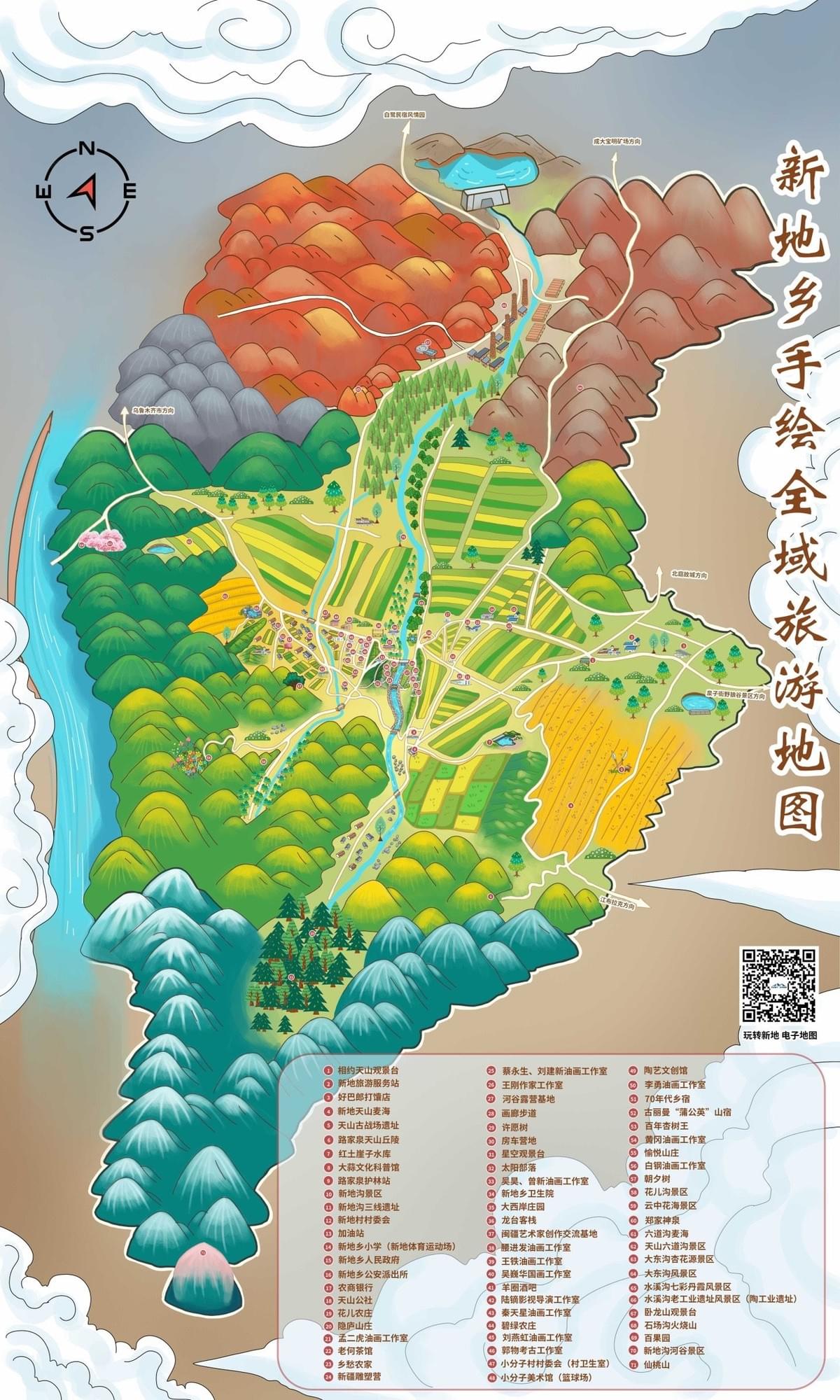
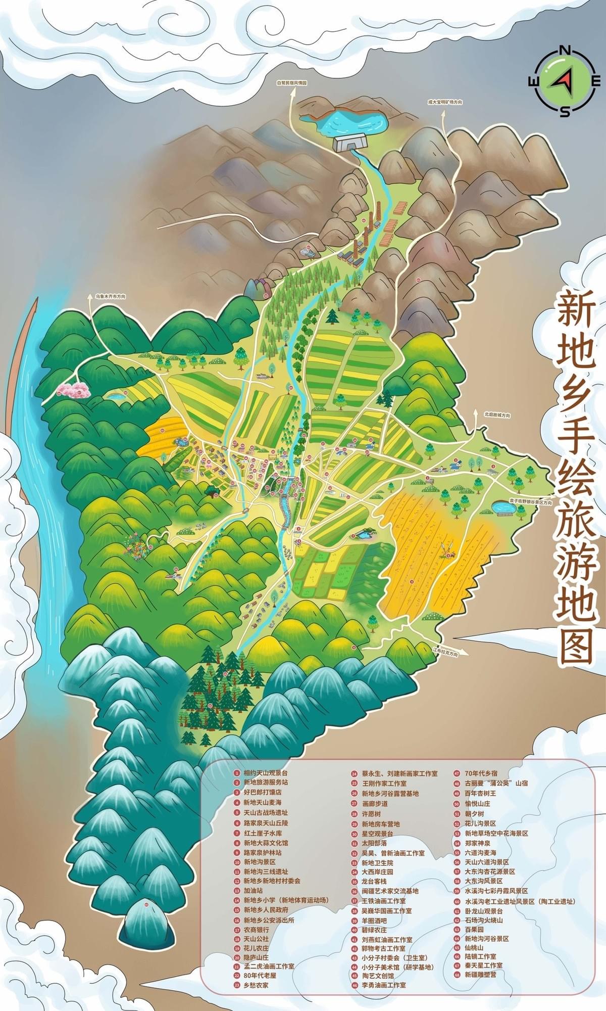
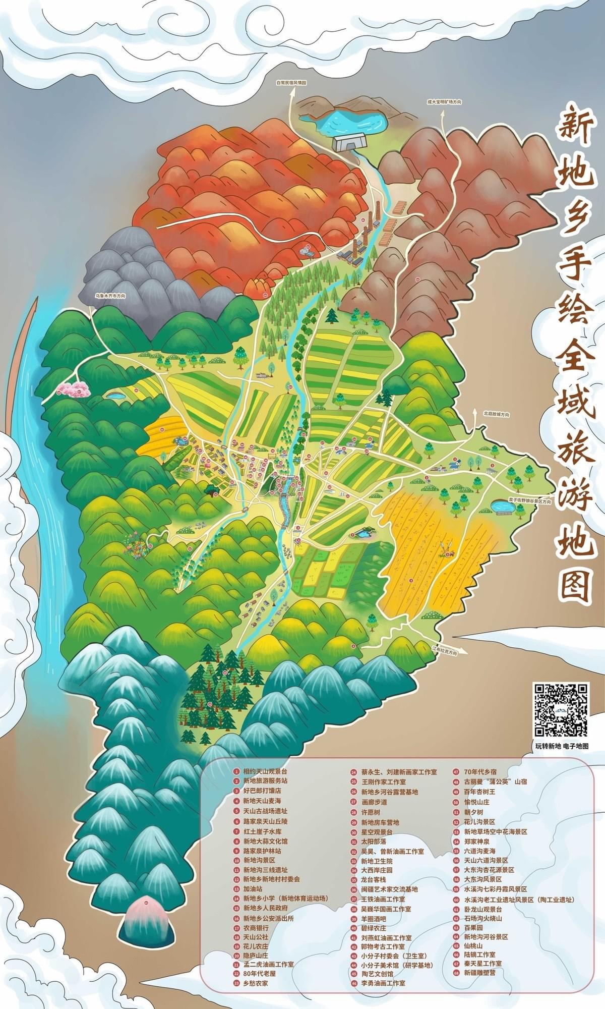
The distinctive aesthetic of the Xindi Township map reflects several deliberate artistic choices:
- Color psychology: The vibrant orange-red mountains create visual hierarchy while green valleys and blue-tinted distant ranges establish depth
- Cultural integration: Traditional Chinese painting techniques influenced the depiction of cloud formations and mountain silhouettes
- Agricultural representation: Distinctive striped patterns in yellow-green hues clearly delineate farming areas, highlighting this important aspect of local life
- Water features: The winding blue river serves as both geographical reference and visual anchor that ties different regions together
- Typography selection: Calligraphy-inspired fonts for Chinese characters honor local aesthetic traditions
Each element was carefully considered not just for beauty, but for how it would enhance a visitor's understanding of the landscape.
Digital Implementation Process
Though the final product appears hand-crafted, modern tools played a crucial role in its development:
- Preliminary sketches: Artists created initial concepts based on geographical data and field notes
- Color palette development: A unified color scheme was established that balanced visual appeal with practical map reading
- Digital illustration: Using specialized software, artists created base layers representing major terrain features
- Icon creation: Custom icons were designed for attractions, settlements, and amenities
- Legend development: A comprehensive yet intuitive legend system was incorporated
- Integration of digital elements: QR codes linking to additional online information were strategically placed
- Typography integration: Chinese and English text was carefully positioned for readability without overwhelming the visual elements
This hybrid approach allowed for precision while maintaining the warm, organic feel of traditional hand-drawn maps.
Client Feedback and Refinement
The collaborative spirit continued throughout the creation process:
- Initial concepts were presented to township officials for early feedback
- Adjustments were made to accurately represent geographical features
- The emphasis on certain attractions was calibrated based on tourism priorities
- Color balancing ensured the map would reproduce correctly across different media
- Final approval involved multiple stakeholders to ensure all township interests were represented
This iterative process ensured the map would effectively serve its intended purpose while delighting visitors with its artistry.
The Final Result
The completed Xindi Township tourism map stands as a testament to Mapful.art's commitment to cartographic excellence. It successfully balances:
- Geographical accuracy with artistic interpretation
- Visual appeal with practical functionality
- Cultural authenticity with tourist accessibility
- Traditional artistry with modern map-reading conventions
Visitors to Xindi Township can now explore with confidence, guided by a map that does more than direct—it inspires curiosity and appreciation for this unique destination.
Conclusion
In our GPS-dominated world, the Mapful.art team's work reminds us that maps can be more than utilitarian tools—they can be windows into the soul of a place. The Xindi Township tourism map exemplifies how traditional cartographic artistry can be reimagined for contemporary purposes, creating something that functions both as a practical guide and as a souvenir worth framing. Through their meticulous process—from consultation to research, artistic development to implementation, and collaborative refinement—Mapful.art has created not just a map, but a visual story of Xindi Township that invites exploration and discovery.